Our Blog - South Florida Surveyor
Ways To Identify A Flood-Prone Area
The Federal Emergency Management Agency, or FEMA, has an online tool that makes it easy to see if your address is in a flood zone. The Flood Map Service Center shows information like flood zones, floodways, and your own home’s risk level. There’s also topographical and infrastructural information about features like levees, coastal barriers, and the base…
What is a Subdivision Survey?
A subdivision survey may be required when an existing property needs to be divided. This can be for any number of reasons. They include, but are not limited to, estate settlement, mortgage requirements, development purposes, or to sell a portion of your property. To prepare a subdivision survey correctly, a boundary survey should be performed…
How Long Does It Take To Get A Land Survey Done?
Land surveying is a scientific technique used to determine a property’s points and distances between them. These points are used to create boundaries for ownership and establish land maps. Surveyors use physics, mathematics, engineering and law to establish these land boundaries. The time it takes to get a land survey honestly depends on your type…
What is a Total Station?
A modern surveying instrument that integrates an electronic theodolite with an electronic distance meter is called a total station. A theodolite uses a movable telescope to measure angles in both the vertical and horizontal planes. For instance, they come in two different types. The first is transit, which rotates in a full circle in the…
When should you have your land surveyed?
If you’re going to be selling or buying land, it’s a good idea to make sure it’s been surveyed recently. An up-to-date and accurate survey of the land will make certain that the legal property lines listed on the deed are correct, and any discrepancies between neighboring land owners can be addressed promptly. Most lenders…
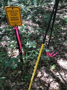
How is a Survey marked?
Discover how a land survey is marked by the experts at Principal Meridian Surveying, Inc. in South Florida.
What is a Wetland Survey?
A wetland survey establishes the location and size of a wetland in order to follow proper federal, state, and local regulations. In south Florida, a wetland is an area inundated or saturated by surface water with a large presence of vegetation typically grown within saturated soils. The first step of wetland delineation in south Florida…
What is a Construction Survey?
A construction survey in the South Florida is used to determine reference points on a property that will provide guidance to the workers on a construction site. These surveys are extremely important and a necessity for every construction site; whether for commercial development, residential development, or state and federal development projects. Therefore, companies that provide…
What is a Mortgage Survey?
A mortgage survey in South Florida is typically used when purchasing a new residential property or commercial property, but can be used with any property purchase that requires a mortgage. Therefore, it will include a physical inspection of the home, building, or structures located on a specific property. As your South Florida mortgage surveyor specialist,…
What is a Tree Survey?
Tree location surveys are an assessment of the different types of trees on a forested piece of land that is currently under consideration for development. For instance, if you are going to build on land or landscape an area and your project will require the removal of several trees, you’ll need a trusted Arborist to…
- « Previous
- 1
- 2
- 3
- Next »


